Current Flood Forecast Map
Tweet
👉 The Current Flood Forecast Map displays flood forecasting for the next 1 to 3 days, offering an overview of flood probability.
📅 Updated On: Mar 20,2026 UTC
👉 It is generated using daily updated flood forecast data from the Copernicus Emergency Management Service, helping communities stay informed and prepared.
Legend:
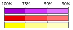 👉 The map shows three levels of flood risk:
Inundated areas for flood events with a return period of 100 years (Source: Copernicus Emergency Management Service)
✍️ Suggest Features
📅 Updated On: Mar 20,2026 UTC
Legend:
👉 The map shows three levels of flood risk:
- Yellow for a 2-year flood probability
- Red for a 5-year flood probability
- Purple for a 20-year flood probability
Each flood level is further divided into three subcategories based on the highest chance of flooding in the first 3 days of a 30-day forecast:
- 30-50% probability
- 50-75% probability
- 75-100% probability
Inundated areas for flood events with a return period of 100 years (Source: Copernicus Emergency Management Service)
✍️ Suggest Features
Please Note:For zoom levels below 6, the resolution is reduced for better visibility. The maximum available resolution is displayed at zoom level 6 and above, which is approximately 9 km.
Disclaimer: The Current Flood Forecast Map is for informational purposes only and is generated using data from the Copernicus Emergency Management Service. It is not an official early warning, as only national or regional authorities have the authority to issue warnings within their areas of responsibility.